Line of Actual Control (LAC) : India & Tibet Border Updates


I would say we merge BSF, SSB & ITBP. That gives the new force an already existing air wing (BSF airwing). It cuts down the fixed costs by 1/3rd. Gives more budget flexibility for more numbers. And it will finally allow the new border force to have it's own airwing along LAC.

ITBP has been wanting a helicopter wing for rapid response along LAC for far too long. I wonder if ITBP had the airwing, could we have taken a better care of Chinese?

Our border guards aren''t treated as such by providing it with all the capabilities any such force may need to cater to the various demands made of them in an extremely challenging & fraught environment.

They've treated as an armed police force under the centre. That's essentially what the situation was before 1962 where guarding the border was the responsibility of the local police , post which the BSF ITBP etc were birthed.

As le Francais say - the more things change the more they remain the same.
 
 
Foundation for Strategic Research (.pdf-Fr), may2023 (c.20pages)

See what the troops can't see,​

going where the troops can't go": China's use of drones in the Sino-Indian border dispute​


Summary
1. A HIMALAYAN BORDER DISPUTE AT THE HEART OF SINO-INDIAN TENSIONS​
2. THE CONCEPTUALISATION AND SIGNIFICANCE OF THE USE OF DRONES FOR CHINESE BORDER DEFENCE​
3. DIVERSITY OF MISSIONS AND ASSETS OF CHINESE DRONES ON THE BORDER​
4. THE STRONG PRESENCE OF CIVILIAN DRONES, AN EXAMPLE OF SUCCESSFUL CIVIL-MILITARY INTEGRATION​
5. THE USE OF DRONES AT THE BORDER: LIMITATIONS AND CONSTRAINTS​
ANNEX 1 NON-EXHAUSTIVE LIST OF CHINESE DRONES DEPLOYED ON THE SINO-INDIAN BORDER​

I will only (deepl) translate the introduction and conclusion:

Introduction

In December 2022, Indian and Chinese armed forces clashed again along the Sino-Indian Himalayan border, resulting in dozens of casualties. The two neighbours are fighting over a border that is almost 3,500 kilometres long and, despite the signing of numerous agreements and the creation of coordination mechanisms, incidents are on the increase. Tensions are a daily occurrence and in 2020, a clash resulted in the death of at least 20 Indian and 4 Chinese soldiers.

The Himalayan plateau is very high at an average altitude of almost 4,000 metres. In recent years, in order to strengthen its military presence there, China has built a network of modern infrastructure in the two autonomous border regions of Tibet and Xinjiang. The country has also begun to make extensive use of drones, with a variety of missions, and Chinese state media have begun to report widely on the subject. These drones are becoming so important that in 2021 a Chinese MP - a former commander of a border regiment on the plateau - called for the use of these drones to be strengthened and improved, as they are essential to the operations of the Chinese military because they can, in his words, "see where troops cannot see, hear what troops cannot hear, and go where troops cannot go".

China is the country with the most drone development programmes. However, until now, there has been no English-language work on Chinese drones specifically deployed on the borders, particularly the Sino-Indian border. This note aims to fill this gap by exploiting Chinese sources, particularly in the Chinese language, including articles in the state media, scientific publications, and social networks. This research work therefore aims not only to identify the UAVs deployed and the manufacturers involved, but also to better understand the objectives and difficulties encountered by the Chinese authorities in using them in a uniquely constrained environment, the Himalayan plateau.

The defence of borders is a specific focus for the Chinese authorities because of the complex geographical environments, poor traffic conditions and the difficulty of supporting military operations there. The use of drones therefore lends itself well to the Himalayan topography and, since the 2017 Doklam incident, the People's Liberation Army (PLA) has accelerated the use of drones on the border with India. In this work, we have identified about forty different drones with a variety of missions: mainly logistical transport, but also surveillance, artillery guidance, demining, and even search and rescue of injured personnel.

These are mainly small and medium-sized multi-rotor drones, as well as small helicopter drones. The majority of the drones used are built by civilian, not military, companies, including start-ups. While the well-known manufacturers DJI and AllTech are present, this is also the case for more confidential manufacturers with a key role to play, such as Ziyan, Tuohang and Tiantu. These companies illustrate China's progress in civil-military integration, a national strategy since 2015.


(…)


Conclusion

China's frequent use of drones on the Sino-Indian border, with diversified objectives, has the potential to change the balance of power on the Himalayan plateau to India's detriment. While we have identified some 40 different drones, more could still be identified. It is therefore important to continue to investigate these, and in particular to try to identify even more precisely the different units using these drones, and the nature of the latter.

Beyond that, particular attention should be paid to this concrete and successful example of civil-military integration in the field of drones, a national strategy since 2015. Indeed, the question arises, among others, of the role of industrial alliances, the mechanisms for financing this integration, the partnerships with universities and research institutes, and more broadly the institutional mechanism facilitating it.

The direct involvement of civil manufacturers, internationally known like DJI or more confidential like Tuohang, must also raise questions about international cooperation with these players. Ensuring that French and European technologies do not contribute to the development of Chinese capabilities, both civil and indirectly military, is essential not only to protect French and European scientific and technological potential as much as possible,100 but also to avoid participating in the change in the balance of power between China and its neighbours, particularly India, through ignorance. /deepl
 
  • Informative
Reactions: john0496

Are China and India bound for another deadly border clash?

(chathamhouse, june02)
Imagery of the disputed Aksai Chin territory reveals new Chinese military infrastructure and an increased strategic threat to India
FxmuTctaIAE0EqP


India is facing continuing instability in a Himalayan flashpoint. The region of Aksai Chin has long been contested by India and China and was the site of deadly clashes between the two Asian powers three years ago.
Satellite images taken in the six months from October 2022 show a region increasingly in flux. Where once there were scattered People’s Liberation Army (PLA) checkpoints and rudimentary positions on the Chinese side of the poorly demarcated Line of Actual Control, now there is an established Chinese presence.
It is here that China has built an extensive set of installations, establishing an ecosystem to support its deployments of PLA troops. The images show expanded roads, outposts and modern weatherproof camps equipped with parking areas, solar panels and even helipads.
Claimed by New Delhi as part of Ladakh but administered by Beijing as part of Xinjiang and Tibet, Aksai Chin is home to the Galwan Valley, where 20 Indian soldiers and at least four Chinese soldiers died in a clash in June 2020. As both sides still disagree about the border’s precise location, the danger of an accidental clash escalating into a Sino-Indian crisis between the two nuclear powers is very much present.
For India, this means its armed forces will now have to match a large-scale and probably semi-permanent Chinese presence along the border with Aksai Chin, perhaps for years to come.
A desolate, uninhabited region
A desolate, uninhabited region with frozen peaks and icy lakes, as recently as 2019 Aksai Chin was relatively stable although tense. Meetings between Narendra Modi, the Indian prime minister, and Chinese President Xi Jinping had sought to manage tensions in the Himalayas after a standoff between the two countries in Bhutan in 2017. But all that changed in May 2020 when a number of PLA units made a large-scale incursion into the disputed territory of Aksai Chin, or Eastern Ladakh as India calls it.
Where previously Indian and Chinese foot patrols would meet, exchange words and eventually withdraw, that spring the PLA entered Aksai Chin in force. By the time the Indian Army responded, the PLA had established temporary positions at key sites. It was speculated in the Indian media that vital intelligence had failed to reach local Indian commanders, while those in senior positions allegedly underestimated the intentions of the PLA.
It was only through lengthy negotiations by Chinese and Indian commissioned officers and careful bilateral diplomacy at the foreign minister level that the crisis was prevented from escalating. In the Galwan Valley, a number of PLA bases connected by roads can now be seen leading up from the main standoff site, following the path of the frozen river.
In Raki Nala, a river valley south of the contested Depsang Plains, Chinese outposts are visible, potentially able to block Indian patrols in the area. Meanwhile at Pangong Tso, a saline lake surrounded by jagged peaks and unforgiving ridgelines, a bridge is nearing completion. When finished, it will allow the rapid deployment of Chinese forces from the PLA’s Rutog military garrison to the contested mountain ridges overlooking the lake.
India’s response to the PLA expanded presence has been multifaceted. On the ground, the Indian Army has sought to reciprocate China’s moves. India’s Northern Command has deployed blocking forces that match the Chinese activity and will prevent any further incursion. The Indian Army has also occupied the peaks of several mountains resulting in Chinese withdrawals from sensitive locations, notably around Pangong Tso.
These moves are matched by a sustained diplomatic effort. New Delhi’s priority is to avoid an outright military confrontation with China. Despite the bellicosity of nationalist voices, India’s leadership quietly recognizes the significant challenge Beijing and its modernized armed forces represent.
Wary of being drawn into a military clash, Modi has approached the militarization of Aksai Chin with caution. Guarded statements from his office have been accompanied by the Indian Army favouring lengthy border negotiations, the 18th round of which concluded in April this year.
Hotly debated
The reasons behind China’s sudden move across the Line of Actual Control are still hotly debated. Given the opaque nature of Chinese policymaking under Xi, the true motives are probably only known in the highest echelons. Whatever drove the decision, the PLA is now firmly ensconced in Aksai Chin and looks set to remain there.
Within the region, two areas of Chinese activity are notable that may yet ensure that tensions continue to simmer.
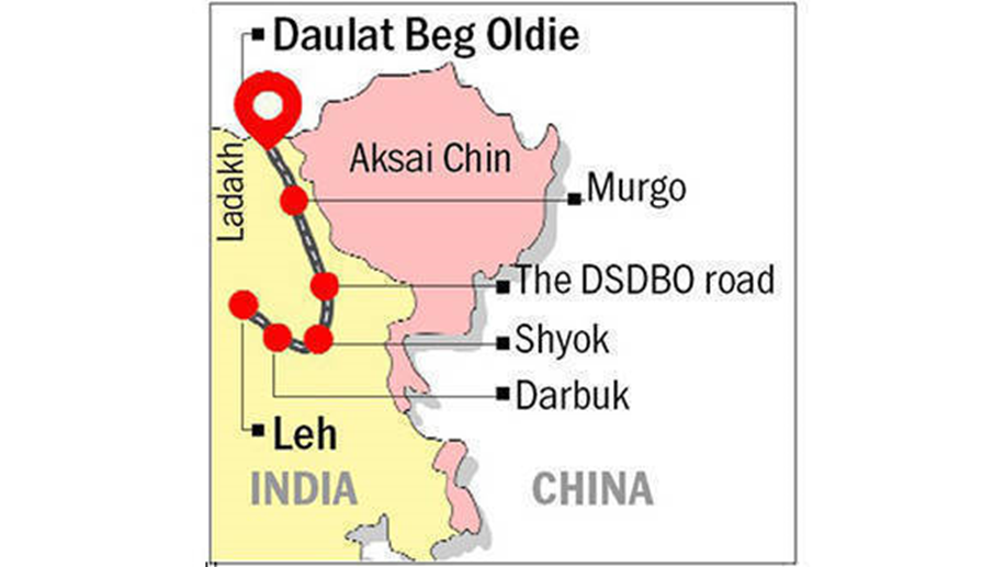
At the Depsang Plains, there continues to be significant Chinese activity. Patrols seemingly intend to put pressure on, and impede the development of, a strategic Indian airstrip at Daulat Beg Oldi, which serves as a logistics and transport base for Indian operations at high altitudes and is the highest airstrip in the world. It crucially supports Indian units arranged not just against China but also against Pakistan.
The second development relates to the proposed Chinese G695 highway intended to link Xinjiang with Tibet. It is due to be completed in 2035 and will run the length of Aksai Chin through the Depsang Plains, south past Galwan Valley and towards Pangong Tso. It represents a strategic artery that will connect the contested region to mainland China and give the PLA a new supply route. The road could also be read as a statement of intent from Beijing to New Delhi, signalling that Aksai Chin will remain a part of China. /end
 
  • Like
Reactions: RASALGHUL