After INS augmented with GPS became mainstream, TERCOM became a redundant solution which requires too much prepration and constant updation of contour libraries. With TERCOM you need to know precisely your launch point and have contour map ready. If contour map changes, TERCOM becomes useless : think deserts. Over water, naturally TERCOM is again useless. For a missile like Brahmos which is supposed to be operated over ocean and over land, TERCOM will be a poor choice. INS with NAVIC augmentation will provide much superior solution for guidance.TERCOM is outdated? Since when? India is incapable of making a credible TERCOM following missile, and suddenly fan boys started hate speech against a technology?

You are using an out of date browser. It may not display this or other websites correctly.
You should upgrade or use an alternative browser.
You should upgrade or use an alternative browser.
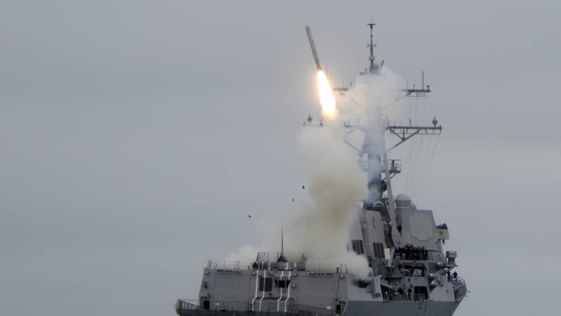
Indian supersonic missile reached Mian Channu in Pakistan : ISPR
- Thread starter Tatvamasi
- Start date

Lastly, remember, I am talking only about TERCOM. For terminal guidance, a related technology called DSMAC is perfectly fine! If you have a picture of target, DSMAC can provide a great terminal guidance.
Lastly, making TERCOM is not at all hard for a country like India. The reason it never happened was because India never went for land based sub sonic cruise missile till very late (even today). TERCOM is an enabling technology for low flying subsonic cruise missiles. India never mastered that so TERCOM never become India's forte. Lately, by GPS + INS, it is now not even needed.
Lastly, making TERCOM is not at all hard for a country like India. The reason it never happened was because India never went for land based sub sonic cruise missile till very late (even today). TERCOM is an enabling technology for low flying subsonic cruise missiles. India never mastered that so TERCOM never become India's forte. Lately, by GPS + INS, it is now not even needed.
If you want to reach destination by announcing your enemy that "you mother *censored*er i am coming for you" INS is enough, if you wanna go there with silence then TERCOM is needed.After INS augmented with GPS became mainstream, TERCOM became a redundant solution which requires too much prepration and constant updation of contour libraries. With TERCOM you need to know precisely your launch point and have contour map ready. If contour map changes, TERCOM becomes useless : think deserts. Over water, naturally TERCOM is again useless. For a missile like Brahmos which is supposed to be operated over ocean and over land, TERCOM will be a poor choice. INS with NAVIC augmentation will provide much superior solution for guidance.
Yeas you need to keep on Updating tour map registry. A job require continuous monitoring by the user, thats big task. I beleive we are yet to reach the levele of US & Russia when comes to upkeepment , thanks to the inheritance of our laziness.
Over the large water body no one uses TERCOM, you need magnetic contour map, which is more difficult in mastering, the things like solar activity, the change in magama flow affecting magnetic profile of warth .
TERCOM is a poor choice for country with less sophistication, & country with loop holes in information gathering. It's a great choice for those nich countries.
Lastly INS type is suited more for ballistic missiles,not for cruise missiles.
40-50 year old US design like Tomahawk can knock on window of your building, I doubt Brahmos have such insane accuracy.Lastly, remember, I am talking only about TERCOM. For terminal guidance, a related technology called DSMAC is perfectly fine! If you have a picture of target, DSMAC can provide a great terminal guidance.
Lastly, making TERCOM is not at all hard for a country like India. The reason it never happened was because India never went for land based sub sonic cruise missile till very late (even today). TERCOM is an enabling technology for low flying subsonic cruise missiles. India never mastered that so TERCOM never become India's forte. Lately, by GPS + INS, it is now not even needed.
TERCOM is really hard for us. we were struggling with Nirbhay for atleast a decade, now we shelved it and going back to drawing board for new design. And who told you that india will not go for sub sonic CMs? We were designing a subsonic missile for all three forces.
Huh? Which part of INS makes announcement? INS is basically passive. INS has NO radio emission at ALL. Heck, it can be implemented (and used to be implemented) as a purely mechanical device. INS with GPS correction also just recieves signals. GPS in itself has no emission of radio signals.If you want to reach destination by announcing your enemy that "you mother *censored*er i am coming for you" INS is enough
On the contrary, TERCOM actually uses a radar alitmeter. So no, TERCOM itself is NOT what is stealthy. You are confusing tercom with a low flying missile. In itself, TERCOM has nothing that makes it stealthier than a INS. You can implement a low flying stealthy missile with purely INS and GPS augmentation. Infact, thats how anti ship missiles like Kalibr operate (INS + DSMAC / Radar seeker).if you wanna go there with silence then TERCOM is needed.
You do not seem to understand guidance systems.
Why waste resources on TERCOM when you can do it using INS?Yeas you need to keep on Updating tour map registry. A job require continuous monitoring by the user, thats big task. I beleive we are yet to reach the levele of US & Russia when comes to upkeepment , thanks to the inheritance of our laziness.
Over the large water body no one uses TERCOM, you need magnetic contour map, which is more difficult in mastering, the things like solar activity, the change in magama flow affecting magnetic profile of warth .
TERCOM is a poor choice for country with less sophistication, & country with loop holes in information gathering. It's a great choice for those nich countries.
Lastly, where you got this idea that a country needs to be very sophosticated to develop TERCOM? Nothing like that. Practically any country can develop TERCOM if they need to. Underlying technology is very simple. Its just a radar altimeter and a reference library to derive course correction.
Wrong. Practically EVERY cruise missiles uses INS. Some use TERCOM to enhance INS, instead as the only guidance system, though mostly all of them support GPS instead. Many missiles have variants of practically all kind of guidance systems. Though modern Fiber Optic based INS with GPS/GLONAS/BEIDOU provide excellent guidance with very little error and can be used practically on any place on the earth.Lastly INS type is suited more for ballistic missiles,not for cruise missiles.
Infact INS is the corner stone of all auto-pilot systems. Cruise missiles for all practical purposes are "flying bomb" (contrast to ballistic missiles which are "falling bombs").
Where did I said INS make emmision & not passive? Simple logic,with INS missile cannot fly tree top, it needs to go high like an aircraft. If enemy is capable of tracking your aircraft,it can track such missiles tooHuh? Which part of INS makes announcement? INS is basically passive. INS has NO radio emission at ALL. Heck, it can be implemented (and used to be implemented) as a purely mechanical device. INS with GPS correction also just recieves signals. GPS in itself has no emission of radio signals.
Are u aware that B2 is using radar while flying? I never said TERCOM enhance any stealth capabilities, it enables the missiles to reach destination by flying low altitude.On the contrary, TERCOM actually uses a radar alitmeter. So no, TERCOM itself is NOT what is stealthy. You are confusing tercom with a low flying missile. In itself, TERCOM has nothing that makes it stealthier than a INS. You can implement a low flying stealthy missile with purely INS and GPS augmentation. Infact, thats how anti ship missiles like Kalibr operate (INS + DSMAC / Radar seeker).
An anti ship missile doesn't need TERCOM. It doesn't need any way point navigation, all it need is homing capabilities & flying low. As u said simple GPS will enable to fly low over oceans. TERCOM & magnetic contour maping requirements comes in to pay when way point navigation is required by flying low, especially while attacking land targets.
Why to waste money on defence at all?Why waste resources on TERCOM when you can do it using INS?
Lastly, where you got this idea that a country needs to be very sophosticated to develop TERCOM? Nothing like that. Practically any country can develop TERCOM if they need to. Underlying technology is very simple. Its just a radar altimeter and a reference library to derive course correction.
I got the idea from my own country's track record on developing the TERCOM capable cm.
It's simple on piloted aircrafts, for missiles you need proper algorithm,proper & update contour map.
I use the word "more suited".Wrong. Practically EVERY cruise missiles uses INS. Some use TERCOM to enhance INS, instead as the only guidance system, though mostly all of them support GPS instead. Many missiles have variants of practically all kind of guidance systems. Though modern Fiber Optic based INS with GPS/GLONAS/BEIDOU provide excellent guidance with very little error and can be used practically on any place on the earth.
Infact INS is the corner stone of all auto-pilot systems. Cruise missiles for all practical purposes are "flying bomb" (contrast to ballistic missiles which are "falling bombs").
Auto pilot system cannot land & take off,are you aware about that? Trea top level waypoint navigation is as difficult as doing an automated landing & taking of. Remember first automated landing is performing over airport,an area free from obstacles.
You are wrong! Dead wrong! There is nothing that prevents a missile guided by INS from flying at tree-top height. The big issue is INS needs correction of drift, irrespective of height it is flying. It has been done using stellar naviation, TERCOM, DSMAC and GPS. Out of this, DSMAC and GPS have been most accurate. So yes, they are replacing TERCOM in cruise missiles.Simple logic,with INS missile cannot fly tree top
Please learn the basics of guidance and multiple technologies used for guidance. Read atleast one article one it. Eg. :DefenceToday -55 - Cruise missile guidance
1. INS the bread and butter of guidance of practically ALL cruise missiles/UAVs since world war 2.
2. TERCOM (most popular in 70s in US cruise missiles) used in conjunction with INS to correct accumulating errors. Its vulnerabilities included change in topography and limitation in selection of terrain over which missile can be flown. You fly a TERCOM guided missile over a flat terrain like a desert or plains and it looses most of its capability to correct accumulating drift in INS.
3. DSMAC, which supplements and later replaces TERCOM. Scene correlation is so powerful that it can guide the missile down to inches in terminal phase! It can also fix drift in INS by comparing scene with a previously obtained one, say from a satellite. You want to do tree-top navigation? DSMAC can do it for you. No need of TERCOM.
3. Finally, GPS, which has largely replaced TERCOM for correcting accumulating error and drift in missiles. It is much more accurate than TERCOM. It is much robust to any change in topography. Advancement in antenna design can nullify effects of jamming.
You want proof of this change of TERCOM->DSMAC/GPS? Look at AGM-158 JASSM/ER/XR (AGM-158 JASSM Archives - Air Force Magazine). It used INS + GPS for most of its navigation and guidance and also uses IR camera based Automated Target Recognition, an advancement from Scene matching and correlation, in the sense it can detect individual objects in a scene and not just match scene.
Hi @Sahoo, your post is very informative, but I have a doubt,3. Finally, GPS, which has largely replaced TERCOM for correcting accumulating error and drift in missiles.
GPS gives the position of the missile and the missile can correct its direction if it veers off the expected path. But doesn't the GPS only have 2D component? Like say what we use in our phones or cars. The missiles will require a 3D position to locate themselves, right? Is the military GPS different?
I doubt it makes sense to invest in what is essentially a 70s guidance technology. Though given how DRDO works, it may just do it and you may get your wish. Look at evolution of Tomohawk (ground attack variants, leaving anti ship variants for obvious reason).Why to waste money on defence at all?
I got the idea from my own country's track record on developing the TERCOM capable cm.
It's simple on piloted aircrafts, for missiles you need proper algorithm,proper & update contour map.
Tomahawk | Missile Threat
The Tomahawk is an intermediate-range, subsonic cruise missile that is launched from U.S. Navy ships and submarines. It provides a long-range, deep strike capability. The Tomahawk can carry either conventional or nuclear payloads, though policy decisions have phased out their nuclear role...
 missilethreat.csis.org
1970s-80s
Block I (BGM-109G, TALN) and Block II ()
INS + TERCOM
1980-early 90
Block III
Uses GPS based navigation and removes time wasted in programming TERCOM (80 hours to 1 hour).
You can estimate altitude using GPS. Basic maths in GPS calculation is triangulation using timing of the signal recieved from many different sources ie satellites. If you assume an ellipsoid shape of earth, you can estimate height as well. That being said, aerospace industry has typically used barometer based altitude measurements., AFAIK. The reason is because aerospace industry or airlines are more worried about relative separation of aeroplanes in same region, even though pressure can differ from day to day. So barometric altimeter provide an excellent measurement of relative altitude. Lastly, radar altimeter (which are also used in TERCOM based naviation systems) also provide a very accurate measurement of altitude. I am not 100% sure in cruise missile which of the above method are used. Likely they use more than one.Hi @Sahoo, your post is very informative, but I have a doubt,
GPS gives the position of the missile and the missile can correct its direction if it veers off the expected path. But doesn't the GPS only have 2D component? Like say what we use in our phones or cars. The missiles will require a 3D position to locate themselves, right? Is the military GPS different?
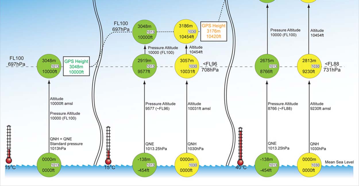
GPS versus barometric altitude – the definitive answer
What's 'GPS altitude' and what's 'barometric altitude'? And what's the difference? And does it matter? This article explains all you need to know about the 'barometric versus GPS altitude' issue<
 xcmag.com

Altimeter is used in cruise missiles.I doubt it makes sense to invest in what is essentially a 70s guidance technology. Though given how DRDO works, it may just do it and you may get your wish. Look at evolution of Tomohawk (ground attack variants, leaving anti ship variants for obvious reason).
Tomahawk | Missile Threat
The Tomahawk is an intermediate-range, subsonic cruise missile that is launched from U.S. Navy ships and submarines. It provides a long-range, deep strike capability. The Tomahawk can carry either conventional or nuclear payloads, though policy decisions have phased out their nuclear role...
1970s-80s
Block I (BGM-109G, TALN) and Block II ()
INS + TERCOM
1980-early 90
Block III
Uses GPS based navigation and removes time wasted in programming TERCOM (80 hours to 1 hour).
You can estimate altitude using GPS. Basic maths in GPS calculation is triangulation using timing of the signal recieved from many different sources ie satellites. If you assume an ellipsoid shape of earth, you can estimate height as well. That being said, aerospace industry has typically used barometer based altitude measurements., AFAIK. The reason is because aerospace industry or airlines are more worried about relative separation of aeroplanes in same region, even though pressure can differ from day to day. So barometric altimeter provide an excellent measurement of relative altitude. Lastly, radar altimeter (which are also used in TERCOM based naviation systems) also provide a very accurate measurement of altitude. I am not 100% sure in cruise missile which of the above method are used. Likely they use more than one.
GPS versus barometric altitude – the definitive answer
What's 'GPS altitude' and what's 'barometric altitude'? And what's the difference? And does it matter? This article explains all you need to know about the 'barometric versus GPS altitude' issue<
Which, on the inside, uses GPS/barometer/radar to measure height.Altimeter is used in cruise missiles.
Top Air Force officer 'blameworthy' in accidental missile firing on Pak: Report
Apparently from Shukla's theorizing of an LACM Brahmos A being fired , we're back to where we started. It was a ground launch .
Apparently from Shukla's theorizing of an LACM Brahmos A being fired , we're back to where we started. It was a ground launch .

IAF completes inquiry into accidental missile firing incident
Separately, the Philippines activates the first battalion that will induct the BrahMos missile system next year
Several officials with knowledge of the missile system stated that there were a series of checks and balances built into the high-end missile system, while ruling out the possibility of a technical defect. “There are a series of software locks which are authorised at various levels, after which there are two manual keys before the countdown can be initiated,” one of the officials explained, also on condition of anonymity. There is a high-level of redundancy built into the system, another official said.
As some one pointed out here earlier, this missile launch could be a brilliantly executed Pakistani operation.